Introduction
If you’re looking for quick information on the Storm Prediction Center, here’s what you need to know:
- Purpose: Forecasts the risk of severe weather
- Focus Areas: Tornadoes, hail, severe thunderstorms, hazardous winter and fire weather conditions
- Products Issued: Convective outlooks, severe thunderstorm watches, tornado watches, mesoscale discussions
- Key Role: Enhances public safety by providing accurate and timely weather forecasts
The Storm Prediction Center (SPC) is crucial for predicting severe weather and protecting lives and property. Understanding how they operate and their importance can help you take the necessary precautions to minimize risks and manage insurance claims effectively.
SPC, originally formed from the Weather Bureau’s research and prediction units, has come a long way since its inception in 1948. Today, the center provides essential weather forecasts for events like tornadoes, hailstorms, and severe thunderstorms.
It’s essential to know how SPC operates and why it’s vital, especially if you are responsible for large properties or manage infrastructure that can be severely impacted by extreme weather.

What is the Storm Prediction Center?
The Storm Prediction Center (SPC) is a critical part of our nation’s severe weather forecasting system. It plays a key role in predicting and alerting the public about severe weather events like tornadoes, thunderstorms, and hailstorms. Understanding how the SPC works can help you better prepare for these potentially dangerous weather conditions.
Forecasting Severe Weather
The SPC is responsible for forecasting severe weather across the contiguous United States. This includes issuing warnings for tornadoes, severe thunderstorms, and other hazardous weather conditions. The center uses advanced technology and a variety of data sources to create accurate forecasts.
Tornadoes and Thunderstorms
Tornadoes and severe thunderstorms are among the most significant threats that the SPC monitors. Tornadoes, with their powerful winds and potential for destruction, require precise and timely warnings. For example, in 1948, two officers at Tinker Air Force Base successfully predicted a tornado, which led to the establishment of the SPC. This marked the beginning of systematic tornado prediction.
Severe thunderstorms, which can produce damaging winds, large hail, and heavy rain, are another focus of the SPC. These storms can cause significant damage to property and infrastructure. The SPC issues convective outlooks, which are forecasts that predict the likelihood of severe thunderstorms over a specific period.
How SPC Issues Forecasts
The SPC uses a three-stage process to refine severe weather forecasts:
- Broad-Scale Forecasts: These initial forecasts identify potential severe weather hazards over a large area.
- More Specific Forecasts: As more data becomes available, the forecasts become more specific, identifying particular areas and time frames where severe weather is expected.
- Detailed Forecasts: Finally, the forecasts provide detailed information about the expected hazards, including the type of severe weather and its potential impact.
This process ensures that the public receives accurate and timely information about severe weather risks.
Real-World Impact
The work of the SPC has real-world implications. For instance, in 2023, meteorologist Liz Leitman became the first woman at the SPC to issue a convective weather watch. This highlights the ongoing advancements and contributions of the center in improving weather prediction and public safety.
Understanding the role of the SPC and how it operates can help you stay informed and prepared for severe weather events. In the next section, we will explore how the SPC uses technology and various forecasting models to predict severe weather accurately.
How Storm Prediction Centers Work
The Storm Prediction Center (SPC) uses advanced technology and various forecasting models to predict severe weather events like tornadoes and thunderstorms. Here’s how they do it:
Technology and Devices
Radar Systems: One of the most crucial tools used by the SPC is Doppler radar. This technology can detect the rotation within storms, which is often a precursor to tornado formation. Doppler radar helps meteorologists identify and track severe weather patterns in real-time.
Satellites: Satellites provide a bird’s-eye view of weather systems. They capture images and data on cloud formations, storm development, and atmospheric conditions. This information is vital for understanding large-scale weather patterns.
Weather Monitoring Systems: Advanced weather monitoring systems collect data on temperature, humidity, wind speed, and atmospheric pressure. These systems include automated weather stations and weather balloons that gather data from various altitudes.
National Weather Service Collaboration
The SPC works closely with the National Weather Service (NWS) to provide accurate and timely weather forecasts. The process begins with a conference call between the SPC and local NWS offices to discuss the potential for severe weather. If necessary, the SPC issues a watch approximation product, followed by a specific county-based watch product from the local NWS office.
Forecast Models
Convective Outlooks: The SPC issues convective outlooks for the next eight days. These outlooks detail the risk of severe thunderstorms and tornadoes. For Days 1 and 2, the outlook includes specific details on the probability of tornadoes, hail, and wind. For Days 3 to 8, the outlook uses a probabilistic scale to indicate the likelihood of severe weather events.
Mesoscale Discussions: These are short-term forecasts that provide information on specific regions where severe weather is becoming a threat. They help forecasters determine whether a watch is necessary and detail the conditions conducive to severe thunderstorm development.
Radar
Doppler Radar: Doppler radar is essential for detecting severe weather. It can identify the rotation within storms, which is a key indicator of potential tornado development. This technology allows meteorologists to issue timely warnings and alerts.
Radar Summaries: The SPC compiles radar summaries at regular intervals. These summaries provide a snapshot of current weather conditions, including the location and intensity of thunderstorms.

Case Study: Tornado Watch in Arkansas
On April 26, 2017, the SPC issued Tornado Watch Number 162 for parts of Arkansas, Louisiana, and Texas. The watch highlighted the risk of tornadoes, large hail, and damaging winds. This timely warning helped residents take necessary precautions and stay safe during the severe weather event.
“Severe storms will move across the watch area through this afternoon, posing a risk of locally damaging winds, large hail, and a few tornadoes. An isolated strong tornado or two is also possible.” – SPC Watch Product
Understanding how the SPC operates and utilizes technology can help you stay informed and prepared for severe weather events. In the next section, we will delve into the different risk levels and how they are determined by the SPC.
Understanding the Risk Levels
High Risk Days
A high risk day is the most severe threat level issued by the Storm Prediction Center (SPC). These days are rare and indicate a significant likelihood of extreme severe weather, such as a major tornado outbreak or an extreme derecho event.
High risk days are characterized by:
- Widespread strong or violent tornadoes: These tornadoes can be on the ground for a half-hour or longer, causing extensive damage.
- Destructive straight-line winds: These winds can be just as damaging as tornadoes, especially in events like derechos.
Fact: High risk days are typically issued only a few times each year. For example, the 1984 Carolinas tornado outbreak on March 28 resulted in 57 fatalities and 1,249 injuries from 24 tornadoes. This was one of the deadliest high risk days on record.
Convective Outlook
The SPC issues convective outlooks to forecast the risk of severe weather over the contiguous United States. These outlooks are categorized from least to greatest threat as: marginal, slight, enhanced, moderate, and high.
- Marginal Risk: Isolated severe storms possible.
- Slight Risk: Scattered severe storms possible.
- Enhanced Risk: Numerous severe storms possible, more intense and concentrated.
- Moderate Risk: Widespread severe storms likely, with significant severe weather possible.
- High Risk: Major severe weather outbreak expected, with a high likelihood of extreme events.
Severe Weather Events
Severe weather events include tornadoes, large hail, and damaging winds. The SPC uses advanced technology and models to predict these events.
- Tornadoes: Tornadoes can cause devastating damage. The SPC issues tornado watches and warnings based on the likelihood of tornado formation.
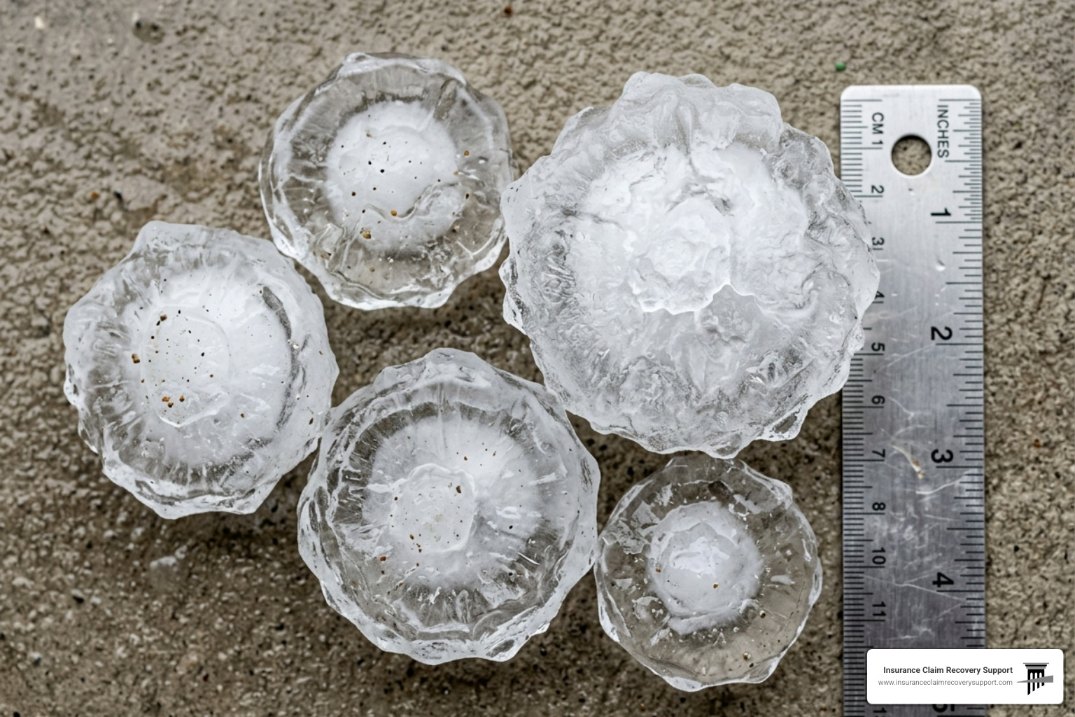
- Hail: Hailstones can be larger than 2 inches in diameter, causing significant property damage.
- Damaging Winds: Winds exceeding 58 mph can uproot trees, tear off roofs, and down power lines.
Historical Example: On April 2, 1982, a tornado outbreak resulted in 63 confirmed tornadoes, including one rated F5, highlighting the severe impact of these events.
Tornado Predictions
Predicting tornadoes involves understanding the atmospheric conditions that lead to their formation. The SPC uses radar, satellite data, and weather models to identify these conditions.
- Radar: Detects rotation in thunderstorms, indicating potential tornado formation.
- Satellite Data: Provides real-time images of weather systems.
- Weather Models: Simulate atmospheric conditions to predict tornado likelihood.
Quote: “Severe storms capable of damaging winds and large hail remain possible over a small part of the upper Texas Coast into southwest Louisiana for a few more hours.” – SPC Day 1 Convective Outlook
Understanding these risk levels and predictions can help you stay informed and prepared for severe weather. In the next section, we will discuss how to prepare for severe weather, including safety tips and creating an emergency kit.
Preparing for Severe Weather
When severe weather is on the horizon, being prepared can make all the difference. Here’s how you can stay safe and protect your property.
Safety Tips
-
Stay Informed: Always keep an eye on weather updates from reliable sources like the National Weather Service. The Storm Prediction Center (SPC) provides regular updates on severe weather risks.
-
Have a Plan: Make sure everyone in your household knows what to do during severe weather. Identify a safe room or storm shelter in your home.
-
Know Your Alerts: Understand the difference between watches and warnings. A watch means conditions are favorable for severe weather, while a warning means severe weather is happening or imminent.
-
Practice Drills: Regularly practice your emergency plan so everyone knows what to do quickly and without confusion.
Creating a Disaster Supply Kit
A well-prepared disaster supply kit can be a lifesaver. Here are the essential items you should include:
- Water and Non-perishable Food: At least a three-day supply per person.
- NOAA Weather Radio: With battery backup to receive emergency alerts.
- First-Aid Kit: Include essential medicines and supplies.
- Flashlights and Batteries: Power outages are common during severe weather.
- Important Documents: Keep copies in a waterproof container.
- Personal Hygiene Items: Soap, hand sanitizer, and sanitary products.
- Extra Clothing and Blankets: To stay warm and dry.
- Tools and Supplies: Basic tools, duct tape, and a whistle to signal for help.
- Pet Supplies: Food, water, and medications for your pets.
Developing an Evacuation Plan
Knowing when and how to evacuate is critical. Follow these steps to ensure your family is prepared:
-
Identify Evacuation Zones: Determine if your home is in a storm surge evacuation zone. You can check your zone here.
-
Plan Routes: Identify multiple evacuation routes in case some roads are blocked or flooded.
-
Shelter Information: Know the location of nearby shelters and have a plan for where you will stay.
-
Communication Plan: Establish how you will contact family members if separated. Make sure everyone knows the plan.
-
Practice Drills: Regularly practice your evacuation plan to make the actual evacuation smoother and less stressful.
Insurance Coverage
Navigating insurance claims can be overwhelming, but preparation helps. Here’s what to keep in mind:
- Review Your Policy: Make sure you understand what your insurance covers and any exclusions that may apply.
- Document Everything: Take photos and videos of your property before and after the storm to provide clear evidence of damage.
- Public Insurance Adjuster: Consider hiring a public insurance adjuster to help you navigate the claims process. They advocate on your behalf to ensure you receive the compensation you deserve.
- Insurance Claim Recovery Support: This service can be invaluable in helping you recover from the storm’s impact. They specialize in maximizing settlements for policyholders.
By following these preparation strategies, you can enhance your readiness for severe weather and safeguard your property and loved ones.
In the next section, we’ll address how to navigate insurance claims for storm damage effectively.
Navigating Insurance Claims for Storm Damage
Dealing with storm damage can be overwhelming. Here’s a simple guide to help you navigate the insurance claims process effectively.
Property Damage
When a storm hits, the first step is to assess and document the damage. Take clear photos and videos of all affected areas. This visual evidence is crucial for your insurance claim. Be specific about the type of damage, whether it’s from wind, hail, or flooding.
Claim Process
-
Immediate Incident Reporting: Contact your insurance provider as soon as possible. Provide a brief overview of the incident, including key details about what happened and the extent of the damage.
-
Detailed Documentation: Gather evidence like photos, videos, and receipts. Collect witness statements if there are any. The more detailed your documentation, the smoother the claims process will be.
-
Insurer’s Assessment: Meet with the claims adjuster for a damage review. Be present during the inspection to ensure all damages are noted.
-
Negotiation: Ensure a fair settlement with professional help. This is where Insurance Claim Recovery Support can be invaluable. They handle all negotiations with your insurance company so you don’t have to.
-
Payment & Restoration: Use settlement funds for repairs and keep track of all costs. Make sure to document all expenses to avoid any discrepancies later.
Settlements
The goal is to get your property back to its pre-loss condition as quickly as possible. However, insurance companies may not always offer a fair settlement initially. This is where Insurance Claim Recovery Support steps in. They specialize in maximizing settlements for policyholders, ensuring you receive the compensation you deserve.
Insurance Claim Recovery Support LLC
Insurance Claim Recovery Support is a public insurance adjuster service that helps property owners navigate the complexities of insurance claims. They prevent unnecessary litigation or appraisal and ensure you don’t face wrongful denial or underpayment.
- Expert Assistance: They assist you throughout the claim process, from documentation to negotiation.
- Fair Settlements: Their goal is to ensure you receive a fair and prompt settlement.
- Support: They stand with property owners in their journey to recovery, providing exceptional service and uncompromising support.
By following these steps and utilizing professional help, you can navigate the insurance claims process more effectively and ensure a fair settlement.
Next, we’ll discuss how to advocate for policyholders and maximize settlements, especially in Texas cities like Austin, Dallas, Fort Worth, San Antonio, Houston, Lubbock, San Angelo, Waco, Round Rock, Georgetown, and Lakeway.
Conclusion
Advocacy for Policyholders
At Insurance Claim Recovery Support, we take pride in advocating for policyholders. Our mission is to support you through every step of the insurance claims process. Severe weather events can be overwhelming, and we understand the stress involved. That’s why we step in to ensure you’re not alone.
Maximizing Settlements
Our team is dedicated to maximizing your settlement. We know the ins and outs of insurance policies and how to document and argue for the fullest possible compensation for your losses. Whether it’s damage from severe thunderstorms, tornadoes, or other storm-related events, we work tirelessly to make sure you get what you deserve.
Focus on Texas Cities
Texas is particularly vulnerable to severe weather, with cities like Austin, Dallas, Fort Worth, San Antonio, and Houston frequently hit by storms. Other cities such as Lubbock, San Angelo, Waco, Round Rock, Georgetown, and Lakeway also face significant risks. Our deep understanding of Texas’ unique weather patterns makes us the perfect partner for navigating storm damage claims in these areas.

Why Choose Insurance Claim Recovery Support?
- Expertise: We specialize in Texas weather-related claims.
- Commitment: Our goal is to ensure you receive a fair and prompt settlement.
- Support: We stand with property owners in their journey to recovery, providing exceptional service and uncompromising support.
By following these steps and utilizing professional help, you can navigate the insurance claims process more effectively and ensure a fair settlement.
For more information on how we can assist you with your insurance claim, visit our Hurricane Loss Types Service Page. Let us help you navigate the path to recovery.